| Popular New Orleans Area
Training Rides
|
|
|
|
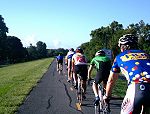
Giro Ride - Saturday & Sunday, 7:00 am (Also an alternate 6:45 group) This is the standard big group weekend training ride in New Orleans. These very informal training rides leave every Saturday and Sunday at about 7:00 a.m. Saturdays tend to be a bit faster and larger than Sundays. Most riders meet at the Starbucks on Harrison Avenue, leaving at 7:00 am, and riding toward the lake on Marconi Blvd., picking up additional riders along Lakeshore Drive. Riders start arriving around 6:30 for conversation and coffee. Feel free to contact the Webmaster for updated information if you are new or visiting. The Giro Ride route, while a good choice for weekend mornings, is not necessarily the best option for solo weekday riding. This 50-mile ride traditionally follows Lakeshore Drive (you can catch the group there if you're a bit late) east to Hayne Blvd., continues on Hayne to Paris Road, and heads south to Chef Menteur Hwy (Hwy 90), turning East to Venetian Isles and returning essentially the same way except for a section on Lake Forest Blvd. and Bullard Ave. (2020). In-season rides can be tough, with sprints at the end of Hayne, Chef Highway, the Service Road, and the top of the two bridges. Group size varies from about 10 in the dead of winter to about 50 in mid-summer. These rides were started many years ago by Glenn Gulotta as a traning ride for his West End team, and subsequently became one of the most consistent training rides in town. A great way to get in a hard training ride and still be home before 10:00. The group does a slow warm-up on Lakeshore Drive on the way out, with the pace picking up rapidly to the high-20's and low 30's once it crosses the Industrial Canal bridge and Casino bridge. Take a look at a 2020 Strava ride to see the route and to get an idea of the speeds and generally what a typical mid-summer Giro Ride is like. This is a traditional training ride that is not organized or conducted by any particular club or bike shop. Alternate 6:45 Group, aka "SaMoRi:" There is a regular group that does the same route as the Giro on Saturdays, starting around 6:45 am from the West End of Lakeshore Drive. This group is usually smaller than the 7 am group and the pace is usually a bit easier and more steady. This ride started in order to accomodate riders who didn't want quite as much intensity as the Giro typically provides. |
River Levee / Lakefront Levee |
NOTE: Levee work began April 2, 2024 that has closed the bike path from the Jefferson Parish line upriver to Almedia Rd. in St. Rose, a stretch of about two miles. It will be closed for over a year. The construction zone can be bypassed via River Road, but traffic and road conditions are not conducive to a weekday group ride. As a result, the Tuesday-Thursday levee rides will likely be shifting to the lakefront (Lakeshore Drive and the Lake Trail). Meeting at the New Orleans Museum of Art for 6 am, hitting Lakeshore Drive around 6:10 or so. Until April 2024 this group was meeting at 6 am at "the pipes" on the levee bike path near Dakin Street, just upriver from the Orleans/Jefferson Parish line. They ride the bike path out to around Ormond and return, about 40 miles round-trip. The pace can get fairly fast depending on who shows up but is mostly smooth single paceline. The bike path atop the Mississippi River Levee, officially called the Mississippi River Trail (MRT), is a nice place to train and take in some scenery, particularly when it's not too crowded (early mornings). This smooth asphalt path starts at Audubon Park near the Zoo and extends upriver, through the Spillway, about 45 miles almost all the way to the Gramercy bridge with no intersections and no traffic except for the occasional police car. It can get a bit windy up on the levee, particularly in the winter, but it still provides one of the only traffic-free places to train. There is also a lakefront bike path between the lake and the levee in Jefferson Parish that starts at Bucktown. That will take you 9.5 miles out to the western edge of Jefferson Parish.
|
| WeMoRi | The WeMoRi (Wednesday Morning Ride) - 5:45 am Wednesday This group starts near Robert's grocery on Toussant Blvd. near Pontchartrain Blvd. on, obviously, Wednesday mornings at 5:45 am for a route that includes a lap of Lakeshore Drive, a loop around City Park via Toussant, Wisner, City Park Avenue, and Marconi Blvd., and a partial lap of Lakeshore Drive over the Bayou St. John bridge, around the Elysian Fields traffic circle, and back over the bridge, ending at the intersection with Marconi on Lakeshore Drive. The ride includes a few sprint points and can get quite fast. For most of the year, this ride is largely in the dark, so bring your lights. |
| Mellow Monday & Friendly Friday | On Mondays and Fridays there is a group that starts in front of the Museum of Art in City Park at 6:00 am for a sometimes easy, sometimes fairly fast ride on a route that goes out to Lakeshore Drive, mostly via Marconi, does a lap of Lakeshore Drive, turning off onto Canal Blvd. for a quick re-grouping opportunity, then back to Lakeshore Drive to Marconi to Harrison to Wisner and back to the museum. This ride usually starts out at conversational pace, gradually increasing in speed along Lakeshore Drive. After passing Marconi the pace eases for an out-and-back on Canal and doesn't usually get fast again until the turn onto Wisner. There's usually a sprint to the top of the overpass for those who are interested. |
Tuesday Loops |
Tuesday Loops is an evening ride started by the Semi-Tough club that happens, obviously, on Tuesdays during Daylight Savings Time. It's basically a 10-mile circuit that is done two or three times, regrouping before each circuit. It starts at the New Orleans Museum of Art (NOMA). It includes Marconi, Lakeshore Drive, the Bayou St. John bridge, around the fountain and back via Wisner Blvd. It can get quite fast once on Lakeshore Drive and will stay that way all the way around to the Wisner Blvd. overpass. Then everyone regroups at the Museum again before starting another lap. |
Lakeshore Drive |
Lakeshore Drive has always been the city's most
popular location for individual and group training. For many riders throughout
the area, a typical weekday training ride involves a warm-up ride to Lakeshore
Drive, 10 or 15 miles along the lakefront, and a cool-down ride back home. The
complete 10-mile out-n-back course offers a good surface, relatively little
traffic, few intersections and pleasant scenery. The Eastern end from the
Seabrook bridge to Bayou St. John is a popular 6-mile loop that has also been
used for the summer afternoon Tuesday/Thursday training races. Riders can be
found training individually or in small groups on weekday mornings and evenings
throughout the year. Feel free to join in with whoever you can catch! |
St. Charles/ Audubon Park |
Some local riders can be found training on St.
Charles Ave. and Carrollton Ave. between S. Claiborne and Jackson Ave., along
the streetcar line , although this route is not for
the faint of heart, and is best before 7:00 a.m. on weekdays. It offers a
reasonably good road surface and is sufficiently wide, but has lots of
intersections and opening doors. The compete out-n-back distance is 10 miles.
Despite the 10 mph speed limit, riders often resort to the Audubon Park loop
when traffic uptown is bad. The long loop that crosses Magazine St. is about 3
miles, but you really can't go faster than about 15 in the front section except
very early in the morning. This ride can be extended by turning onto the new
bike path atop the Mississippi River Levee (see below). In 2013 a bike lane was added on Carrollton Avenue from St. Charles to S. Claiborne and on St. Charles from Carrollton to Nashville Ave. |
| City Park
Loop [SEE A MAP] |
The perimeter of City Park is a popular training route that offers relatively few intersections and a generally good road surface. There are numerous variations of this loop, which can be extended to include a piece of Lakeshore Drive. One circuit follows Wisner, City Park Ave., Marconi, and Toussant, and is popular in mid-winter with riders avoiding the piercing North wind coming off the Lake. The distance around is about 10 miles, but can be shortened by cutting through the park in a couple of places. Wisner Blvd. has a wide shoulder and also a meandering bike path along the bayou. Marconi Blvd. and Toussant were both repaved in recent years with Toussant getting bicycle "share arrows." A separate bike path runs along Marconi from City Park Avenue all the way to Toussant. |
Jefferson Lakeshore Bike Path, Linear Park |
The Linear Park was originally an old road (Hammond Highway), now converted and mostly relocated into a bike path between the lake levee and the lake itself. It runs along the South shore of Lake Pontchartrain
the entire length of Jefferson Parish. In early 2014 the last of the bridges across the outfall canals was finished, and an underpass beneath Causeway Blvd. was added in 2012, so it is now a nice continuous path. You can get on at Bucktown, and at most of
the major North/South streets like Causeway. The path runs all the way to the
West edge of Kenner, then crosses the levee and continues South almost to the
Interstate.
|
Abita Springs & Northshore
|
|
Red Bluff SEE A MAP
|
These legendary training rides will consume much
of your day (it's about an hour and a half drive), but periodic group training
rides to this Mississippi location (click for a map
of the area) can serve as valuable tools for assessing your fitness for
competitive road racing on courses with significant hills. The out-and-back ride south of
Montecello, Mississippi incorporates some significant climbs, even though about
half of the ride is essentially flat. What we're talking about here isn't
exactly Everest, but it will show you what it's like to have to stand up in a
39x21 and wonder how much farther it is to the top (and whether you'll make
it). If you are really looking for a serious workout, an alternate loop of around 33 miles provides much more climbing, and serves as a good test for the masochistic or sadistic rider
(depending on fitness level ). |
![[SEE A MAP]](images/uptwnmap.gif)
![[SEE A MAP]](images/parkmap.gif)
![[Enon-Plainview SEE A MAP]](images/maps/enon_plainview.gif)